History & local legend
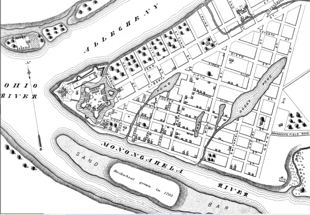
An island once occupied part of the Monongahela River beside downtown Pittsburgh, near the Point. Today boats pass over that reach, but early views and maps show a sandbar with ground high enough to support a crop of buckwheat.
Samuel Durant’s 1876 reconstruction of Pittsburgh in 1795 labels the cultivated patch. University of Pittsburgh geologists later compared such historical views, noting that the island appeared in some and was absent from others. They proposed that flooding had built up the temporary landform.
By the 1820s, a description referred to a bar exposed at low water. The shifting record suggests a feature that changed with the river rather than a permanent island with a stable shoreline.
Sources
- University of Pittsburgh geology field guide, The Island in the Mon, comparison of early maps and flood hypothesis
- Samuel W. Durant, History of Allegheny County, plate IV, 1876 reconstruction of Pittsburgh in 1795, island labeled with crop
- Richard T. Wiley, Monongahela: The River and Its Region (1937), Islands and Their Lack, pp. 75–76
- The Historical Dilettante, Pittsburgh’s Lost Islands, discussion of the island and transcription of the sandbar description in the 1826 Pittsburgh directory


